GPS observations
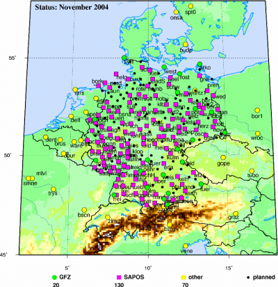
Originally designed for navigation purposes the Global Positioning System can also be used to determine the atmospheric integrated water vapour (IWV) when the position of the GPS satellites and the GPS receiver are precisely known. Since this method has emerged, the number of ground-based GPS receivers organised within networks to derive columnar water vapour is increasing as well as the use of GPS receivers on Low Earth Orbiting (LEO) satellites for water vapour profiling. An overview about current GPS activities is given in Bengtsson et al. (2003). The EUMETNET GPS water vapour programme E-GVAP provides 1-hourly observations from about 400 stations. For GOP the Geoforschungszentrum Potsdam GFZ provides IWV estimates of about 200 stations with 15 min resolution in near real time.
Method
The time the GPS signal needs to travel from the GPS satellite to the GPS receiver is longer than the time calculated from the distance and the velocity of light in a vacuum. The time difference converted to distance, the so called delay, is the original GPS measurement from which the water vapour column is derived. The ratio between the speed of light in the atmosphere and the speed of light in a vacuum is the index of refraction. At microwave frequencies the refractivity depends on the free electron density of the ionosphere and a neutral contribution. The ionosphere can cause delays of several tenths of meters but can be corrected using a dual frequency method, e.g using two GPS signals at 1.2 and 1.5 GHz. The neutral contribution can be further separated into the hydrostatic delay (which can account to 2.3 m but is easily corrected by knowing atmospheric pressure) and the wet delay, the most variable contribution to the GPS signal. Correcting for ionospheric and hydrostatic effects the wet delay can be determined with good accuracy. In order to take the elevation of the GPS satellite into account the wet delay is converted to a zenith direction. The zenith wet delay (ZWD) is closely related to the integrated water vapour with a ratio of IWV /ZWD corresponding approximately to 0.15 (Businger et al., 1996). Further improvements in the accuracy can be obtained by incorporating the effective atmospheric temperature, which can be approximated from the ground-level temperature, in the IWV estimation. Several intercomparison studies have been performed and have demonstrated the potential to measure IWV with an accuracy of 1-2 kg m-2.
As GPS receivers are relatively inexpensive and require low maintenance they are used in large networks within Europe and the http://www.gst.ucar.edu/gpsrg/realtime/. Currently, their potential for climate monitoring, atmospheric model evaluation and data assimilation is being investigated. However, for the latter application, real time data are necessary. Unfortunately, the exact information about GPS satellite positions is difficult to provide in real time. Therefore the accuracy for online values (employing predicted orbits) is lower compared to reprocessed data.
Bengtsson, L. et al. (2003). The use of GPS measurements for water vapor determination, Bulletin of the American Meteorological Society, 84, 1249-1258.
Businger, S., Chiswell, S. R., Bevis, M., Duan, J., Anthes, R. A., Rocken, C., Ware, R.H., Exner, M., VanHove, T. and S. Solheim, F.S. (1996). The promise of GPS in atmospheric monitoring, Bulletin of the American Meteorological Society, 77, 5–18.

